Edinburgh Drone Survey

contact@edinburghdrones.com
or call 0131 364 4590
Established in 2016 Edinburgh Drones has provided drone survey. Our survey and mapping services have helped professional surveyors glean new insights without the risk or working at height or using crewed aviation. We have a great reputation from our clients having helped them develop and deliver their vision to time and budget.

Contact Us

Edinburgh Drone Surveying


Drone surveying has become an increasingly popular tool for businesses across various industries. By using drones equipped with high-resolution cameras and sensors, businesses can survey and map areas quickly and accurately. In this article, we will explore the various uses of drone surveying to market your business and highlight some of the ways you can leverage this technology to gain a competitive advantage.
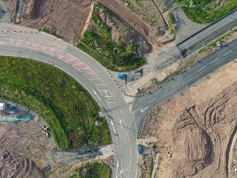
Construction

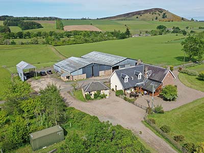
If you're in the construction business, drone surveying can help you with site planning, progress monitoring, and project management. Drones can capture high-resolution aerial imagery and create 3D models of the site, allowing you to track progress and identify potential issues. Drone surveying can also be used to calculate material volumes, which can help you with budgeting and procurement. By using drone surveying, you can show potential customers how you are using the latest technology to optimize your construction projects and ensure their success.

Real Estate

If you're in the real estate business, drone surveying can help you create compelling marketing materials and attract more buyers. Drones can capture high-resolution images and videos of properties from various angles, providing potential buyers with a better sense of the property's features and surroundings. Drone surveying can also be used to create 3D models and virtual tours of properties, giving buyers a more immersive experience. By using drone surveying, you can show potential customers how you are providing innovative and effective ways to market their properties.

Agriculture

If you're in the agriculture business, drone surveying can help you monitor crop health and optimize yields. Drones equipped with multispectral cameras can capture detailed images of crops, which can be used to detect issues such as nutrient deficiencies, water stress, and pest infestations. This data can be used to make informed decisions about crop management, resulting in higher yields and better quality produce. By using drone surveying, you can showcase to potential customers how you are using the latest technology to improve crop health and productivity.

Mining
If you're in the mining business, drone surveying can help you with exploration, planning, and monitoring. Drones can capture high-resolution images and create 3D models of mining sites, allowing you to identify potential mineral deposits and plan extraction strategies. Drone surveying can also be used to monitor site conditions and track progress, ensuring compliance with safety regulations and optimizing productivity. By using drone surveying, you can show potential customers how you are using the latest technology to improve the efficiency and sustainability of your mining operations.

Environmental Monitoring

If you're in the environmental monitoring business, drone surveying can help you with site assessments and monitoring. Drones can capture high-resolution images and data from various sensors, allowing you to identify and monitor environmental issues such as pollution, erosion, and land degradation. Drone surveying can also be used to create detailed maps and models of sites, providing valuable information for environmental planning and restoration projects. By using drone surveying, you can show potential customers how you are using the latest technology to protect and preserve the environment.

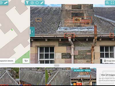
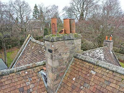
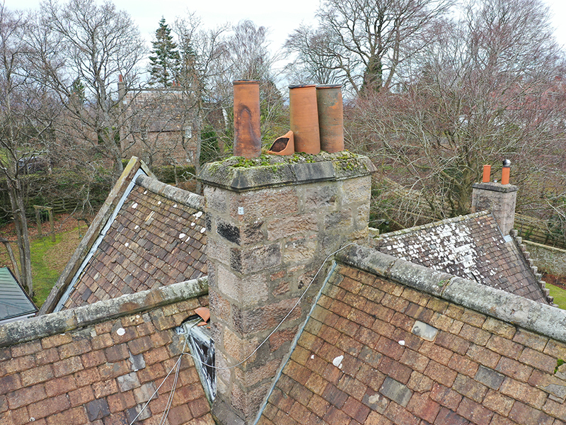
Infrastructure Inspection

If you're in the infrastructure inspection business, drone surveying can help you with inspections of bridges, dams, and other critical infrastructure. Drones can capture high-resolution images and videos of structures, allowing you to detect issues such as cracks, corrosion, and deformation. Drone surveying can also be used to create 3D models and point clouds of structures, providing valuable data for maintenance and repair projects. By using drone surveying, you can show potential customers how you are using the latest technology to ensure the safety and reliability of critical infrastructure.

Drone surveying has become an essential tool for businesses across various industries. By using drone surveying, businesses can optimize their operations, improve productivity, and gain a competitive advantage.

Example Uses


Drones have a diverse number of uses a number of which we have undertaken. A variety of use cases are listed below which we either undertake or can suggest an operator from our 3rd party network. We have helped universities map glaciers in Peru through to aiding aerospace clients with classified research.

Marketing

Commercial property; Scottish tourism; business marketing; new products; headquarters and campuses; outdoor sports; FPV video; indoor drone filming.

Events

Sporting events; race events; motorsport events; live video feed; weddings; country shows.

Industrial

Estate management; roof inspections; solar panel inspection; HVAC inspection; thermography; structural inspection; power line inspection; cable inspection.

Farm & Environmental

Crop survey; crop spraying; habitat survey; wildlife counting; water sampling; multispectral survey; landfill methane measurement; carbon emmisions.

Construction, Survey & Mining

3D modeling; BIM; topographic survey; LiDAR survey; stockpile measurement; volumetric measurement.

Custom

Drone delivery; sky crane; lightning protection testing; light shows; water sampling; air quality measurement; non destructive testing; telecoms inspection.

Our Portfolio


A small selection of our work. See our social channels listed below for more examples of our recent client work.

Why Hire Us


We differentiate ourselves from other operators based on the quality and delivery of our work.
Letting us take take care of your drone task lets you get back to concentrating on what you do best.

Satisfied Customers

We have several customers championing us after working for them - see our reviews

Professionalism

All our pilots are trained, insured and follow local regulator guidelines on current safe drone operations

Problem Solving

Outside the box creative solutions when drones may not be the best tool to complete the task safely

Customer Service

We have a customer centred culture, our management system keeps customers clearly informed through the process

Google reviews
Trustpilot reviews
Facebook reviews

Current Prices


Drone service prices aren't always the same as every task is different. We will always be transparent on what the job requires to perform it safely and on time. Our basic rates below include full planning including any communications with sensitive sites such as airports or stadiums, additional fee's may include travel expenses beyond Edinburgh or additional staff and equipment. Half and full day rates include planning, prep, travel and content delivery. We occasionally announce special offers on Facebook and Insta and welcome you to follow us on those channels.

Half Day

£250
  • Property Marketing
  • Business Marketing
  • Private Roof Inspection
  • Events & Weddings

Full Day

£450
  • Film and TV
  • Major Events
  • Energy & Infrastruture
  • Mapping & Environment

Call For Quote

£---
  • Bespoke Solutions
  • Time Sensitive Tasks
  • Ongoing Contracts
  • Bulk Discounts

Benefits


There are several benefits to using drone services to aid an organisational task or create a new one. Factors to consider include:

Cost Effective

Compared to traditional methods of aerial photography or inspection, using drones can be more cost-effective. Drones require fewer personnel and resources, and they can cover large areas quickly and efficiently.

Improved Safety

Using drones for inspections or other tasks can reduce the need for human workers to perform dangerous or difficult tasks. This can improve safety and reduce the risk of accidents or injuries.

Versatility

Drones can be equipped with a variety of cameras, sensors, and other tools, making them suitable for a wide range of applications. They can be used for photography and videography, mapping and surveying, inspections, search and rescue, and more.

Accuracy

Drones can provide high-quality, detailed data and imagery, which can improve accuracy and reduce the risk of errors. This is particularly important for applications such as mapping and surveying.

Speed & Efficiency

Drones can cover large areas quickly and efficiently, which can save time and resources. This is particularly useful for applications such as inspections or search and rescue, where time is of the essence.

Overall

using drone services can provide a cost-effective, efficient, and safe solution for a wide range of applications. As technology continues to evolve, drones are likely to become even more versatile and valuable in a variety of industries.

Contact Us

5 South Charlotte Street, Edinburgh EH2 4AN

Phone: (0131 364 4590)